WSG supports the rollout of the Coastal Storm Modeling System (CoSMoS) in Washington state
From the Summer 2024 Sea Star
By Alison Lorenz, WSG Science Writer
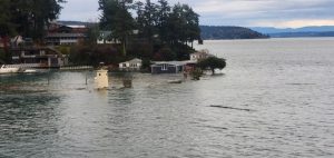
Flooding caused by a king tide in Gig Harbor in 2022. Photo submitted by David Barker to the King Tides program via MyCoast.
The first time Ian Miller, Washington Sea Grant (WSG) coastal hazards specialist, heard about CoSMoS, he was in graduate school at the University of California, Santa Cruz. This was around 2009, when the first iteration of CoSMoS was being used to model coastal storms in southern California. While Miller was interested at the time, he couldn’t have known how soon CoSMoS — a computer modeling system created by the United States Geological Survey (USGS) — would reappear in his career.
In 2011, Miller joined WSG. The next year, he began his first sea level rise planning project with the Jamestown S’Klallam Tribe. In his role as coastal hazards specialist, he was responsible for providing technical assistance to the Tribe, helping them to understand where and how sea level rise would most impact them. The first step was to develop a map showing the risk of sea level rise or coastal flooding to specific areas. Since that time, Miller again and again found himself in a similar position: collaborating with local communities and jurisdictions on shoreline planning, only to have that first step — creating sea level rise or coastal flooding maps — become a hurdle.
After advisory discussions with Miller, local jurisdictions would often realize they lacked the type of expertise to create the maps themselves. The maps required technical capacity, like GIS expertise and localized data gathering, that many jurisdictions simply didn’t have. That meant they needed to hire consulting firms to do the work for them. Hiring consultants meant finding funding to do so, which meant syncing with budget cycles and justifying the project to decision makers, until all of a sudden years went by — and the jurisdiction’s shoreline planning project was still stuck on step one.
“If we’re going to be doing a lot of this, it would be really useful to have a tool rather than building it ourselves every time,” Miller remembers thinking.
CoSMoS is just that tool. CoSMoS stands for Coastal Storm Modeling System. It’s a numerical modeling system uniquely capable of interpreting the physics of compound flooding — the combined impacts of coastal storms, sea level rise, and river flooding — down to the local scale. As a result, planners, managers and residents can use the new system to help them understand the impacts of coastal flooding to property, homes and businesses.
Fortunately, interest in CoSMoS was big enough in California that it eventually drew attention in Washington. Both states now mandate that local jurisdictions assess and plan for vulnerabilities on their coasts. And after a positive experience with Sea Grant in California, it made sense for USGS to partner with WSG to connect jurisdictions and communities with CoSMoS. WSG was well-positioned to provide outreach, education and technical assistance as the tool expanded farther north. In Washington, WSG is a known connector already working with local partners to conduct sea level rise and coastal planning; in CoSMoS, USGS created a free, accessible tool that could make this planning easier than ever. With these mutual benefits, the partnership was born.
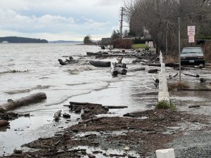
King tide flooding at the Guemes Island ferry lot, 2022. Photo submitted by Sally Peyou to the King Tides program via MyCoast.
“It was a no-brainer for WSG to be involved in an education effort for CoSMoS,” says Chandler Countryman, WSG resilience and adaptation specialist. “We’re already a group that people turn to for the best science available, and for resources around these questions. We are already involved in so many communities and showing up to local meetings — so it’s very easy for us to provide the outreach and public education about CoSMoS to all those places that we’re already showing up to.”
Washington’s coastline is home to diverse communities, important infrastructure and industry, and habitat critical for commercial fisheries, Tribal Treaty Rights and public well-being. But the same things that make the coastline appealing put it at risk of flooding. Between sea level rise, storms, tides and overflowing rivers, many factors drive flood events. Yet whether it lies within a river floodplain or holds important municipal infrastructure, each piece of shoreline has unique and valuable traits that flooding can impact in different ways.
CoSMoS has several key features that make it especially useful for examining these potential impacts. First, the system incorporates wind, atmospheric pressure, and sea surface temperature data from global climate models. It then combines these data with models of local water levels that include factors like tides and storm surge. Finally, CoSMoS incorporates a wide range of sea level rise scenarios, allowing planners to view potential flooding impacts in both the near and long term.
As coastal flooding in Washington is often caused by a combination of factors — a winter storm combining with a king tide, for example — CoSMoS is well suited to the needs of planners here. “The model couples together a lot of different coastal impacts. It’s not just sea level rise data, just wave data, just storm data — it’s all of those things together, and all of those things can be factors in the flooding that people experience,” says Sydney Fishman, coastal management specialist at WSG. “The fact that CoSMoS can model all of these factors, that makes it especially important for our geography.”
Predicting local flooding impacts with this level of precision has many uses, especially to local planners. A growing number of counties are beginning to actively plan for future higher water levels, more intense storms, and the flooding they bring. Data such as those from CoSMoS and its associated web tools help planners determine which assets — from roads to ports and parks — are most at risk, and which are most in need of action. CoSMoS has even been combined with other information to show, for example, disparities in local socioeconomic vulnerability in flood exposed areas. With information in hand, planners can begin to determine which mitigation and adaptation strategies will work best to protect their particular communities.
In their effort to spearhead outreach efforts, WSG staff will be rolling out the modeling system, connecting it to communities and helping them implement it. Miller is hopeful that with CoSMoS, more jurisdictions and tribes will soon be able to access the information they need to start planning for sea level rise.
###
Washington Sea Grant, based at the University of Washington, helps people and marine life thrive through research, technical expertise and education supporting the responsible use and conservation of coastal ecosystems. The National Sea Grant College Program is part of the National Oceanic and Atmospheric Administration, U.S. Department of Commerce.
Join the conversation: instagram.com/waseagrant and Facebook.com/WaSeaGrant.
AUG
2024