Created by the United States Geological Survey (USGS) and supported by Washington Sea Grant (WSG), the Coastal Storm Modeling System (CoSMoS) recently released flood hazard products for shorelines in King and Pierce Counties
January 14, 2026
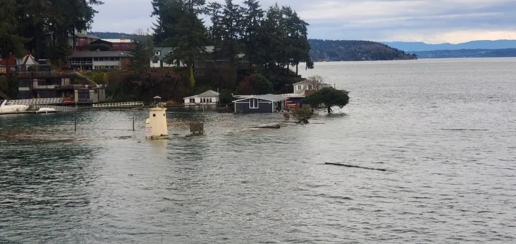
From flooding to eroding shorelines, extreme storms increase the hazards faced by coastal communities. Recognizing these threats, planners and managers around Washington are assessing the vulnerability of their communities and planning for impacts – in particular, the impacts of coastal flooding due to storms, water level changes, and river flooding. But planning for coastal flooding can be difficult when so many different, compounding factors affect where water flows and how high it gets.
The Coastal Storm Modeling System (CoSMoS) is one tool that can help. CoSMoS is a numerical modeling system uniquely capable of interpreting the physics of compound flooding from coastal storms and river flooding – down to the local scale. As a result, planners, managers and residents can use products from the new system to help them visualize and understand the risk of exposure from coastal flooding to county infrastructure, homes, and businesses. New results are now available for King and Pierce counties, covering many local jurisdictions and Tribal lands. The new results join a suite of products already available through CoSMoS, including overland flooding products for Whatcom County, which were published in February 2024. Groundwater modeling, which can be used to evaluate changes in the water table due to long-term coastal water level changes, is available for all of Puget Sound. USGS is developing these products for other Puget Sound counties and the Pacific coast too – the estimated release schedule is available on the Coastal Hazards Resilience Network website.
Flooding during a king tide (12/27/2022) in Gig Harbor, Pierce County, WA. Photo by David Barker via the MyCoast app.
Puget Sound comprises 2,600 miles of coastline – home to diverse communities, important infrastructure and industry, and natural resources critical for commercial fisheries, Tribal Treaty Rights and public well-being. Much of this coastline is at risk of flooding due to the combination of rising seas, storms, tides and overflowing rivers. Yet whether it lies within a river floodplain or holds important municipal infrastructure, each piece of shoreline has unique and valuable traits that flooding can impact in different ways. CoSMoS has several key features that make it especially useful for examining potential impacts to Puget Sound. First, the system incorporates global-scale atmospheric and oceanographic factors that affect coastal water levels, like wind, atmospheric pressure, and El Niño events. It then combines these data with regional-scale (Salish Sea) and local-scale waves, tides, storm surge, and river hydrology to produce locally-relevant flood hazard maps. Finally, CoSMoS incorporates a wide range of future scenarios, allowing planners to view potential flooding impacts in both the near and long term.
Locally relevant flood hazard maps have many uses, especially to local planners. Many areas within King and Pierce counties already experience periodic flooding and storm damage, and many of the jurisdictions and Tribes in these counties are planning for future extreme storm events and the flooding they bring. Data such as those from the CoSMoS project help planners determine which assets – from roads to ports and parks – are most at risk, and which are most in need of protection. With information in hand, planners can begin to determine which mitigation and adaptation strategies will work best to protect their particular communities.
“We’re excited for the release of more CoSMoS products to users in Washington,” says Sydney Fishman, coastal management specialist at Washington Sea Grant. “It’s great timing, because local governments and Tribes are ramping up their planning efforts around coastal hazards.” Washington House Bill 1181 and the Department of Ecology’s ongoing rulemaking require local governments to plan for rising seas. “More local governments will be doing this work in the next few years as new requirements roll out,” Fishman notes. “CoSMoS products can plug right into these studies, and my colleagues and I at Washington Sea Grant and USGS are here to support planners in using CoSMoS products as they do that work.”
CoSMoS hazard maps can be viewed in the USGS Hazard Exposure Reporting and Analytics (HERA) Multi-hazard Viewer. The HERA web tool also combines hazard maps with asset information to show local socioeconomic impacts from different flooding events. Viewing the data now available for King and Pierce counties in the HERA web tool allows a user to define a flooding scenario and see the exposure risk of particular assets by local jurisdiction. For example, a user can see how many miles of road would likely be flooded during a future storm. The user could even specify roads by type, such as highways, surface streets, or secondary streets.
“CoSMoS fills an important information gap for King County Wastewater Treatment Division (WTD) and other agencies in the region by estimating the combined effects of future storms, sea level rise, and river flooding,” notes Beihua Page, Senior Climate Adaptation Planner at King County WTD. “WTD looks forward to using the King County CoSMoS results to refine our understanding of the vulnerability of our critical facilities to coastal flooding under future environmental conditions. This will allow us to identify adaptation strategies for our assets that are robust across multiple sea level rise and storm scenarios.”
The development of CoSMoS in Washington was supported by funding from King County, Pierce County, and the U.S. Environmental Protection Agency, as well as a long-standing partnership with Deltares.
Products are available to view in the USGS HERA web tool and for download of geospatial hazard data available in one centralized hub.
More information is available at the Washington Coastal Hazards Resilience Network.
Media contacts:
Chandler Countryman, Resilience and Adaptation Specialist, Washington Sea Grant: ccount@uw.edu; T 206.543.7347
Sydney Fishman, Coastal Management Specialist, Washington Sea Grant: sfishma@uw.edu; T 206.543.5051
###
Washington Sea Grant, based at the University of Washington, helps people and marine life thrive through research, technical expertise and education supporting the responsible use and conservation of coastal ecosystems. Washington Sea Grant is one of 34 Sea Grant programs supported by the National Oceanic and Atmospheric Administration in coastal and Great Lakes states that encourage the wise stewardship of our marine resources through research, education, outreach and technology transfer.
Join the conversation: instagram.com/waseagrant and Facebook.com/WaSeaGrant.
JAN
2026