February 27, 2024
Created by the United States Geological Survey (USGS) and supported by Washington Sea Grant, the Coastal Storm Modeling System (CoSMoS) will soon be available for use across Washington state
From rising seas to eroding shorelines and more frequent, intense storms, the hazards faced by coastal communities are only projected to grow. Recognizing these threats, planners and managers around Washington are assessing the vulnerability of their communities and planning for impacts – in particular, the impacts of coastal flooding due to storms, sea level rise, and river flooding. But planning for coastal flooding can be difficult when so many different, compounding factors affect where water flows and how high it gets.
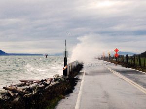
Courtesy of Washington Sea Grant. Photo by Pete Granger.
The Coastal Storm Modeling System (CoSMoS), now expanded to include Puget Sound, is one tool that can help. CoSMoS is a numerical modeling system uniquely capable of interpreting the physics of compound flooding – coastal storms, sea level rise, and river flooding – down to the local scale. As a result, planners, managers and residents can use the new system to help them understand the impacts of coastal flooding to county property, homes and businesses. Whatcom County is the first in Washington state to receive specific projections and results from the tool. And while Whatcom County results were published first, location-specific CoSMoS data will soon be available statewide.
Puget Sound comprises 2,600 miles of coastline – home to diverse communities, important infrastructure and industry, and habitat critical for commercial fisheries, Tribal Treaty Rights and public well-being. Much of this coastline is at risk of flooding due to the combination of sea level rise, storms, tides and overflowing rivers. Yet whether it lies within a river floodplain or holds important municipal infrastructure, each piece of shoreline has unique and valuable traits that flooding can impact in different ways. CoSMoS has several key features that make it especially useful for examining potential impacts to Puget Sound. First, the system incorporates wind, atmospheric pressure, and sea surface temperature data from global climate models. It then combines these data with models of local water levels that include factors like tides and storm surge. Finally, CoSMoS incorporates a wide range of sea level rise scenarios, allowing planners to view potential flooding impacts in both the near and long term.
“The model couples together a lot of different coastal impacts. It’s not just sea level rise data, just wave data, just storm data – it’s all of those things together, and all of those things can be factors in the flooding that people experience,” says Sydney Fishman, coastal management specialist at Washington Sea Grant. “The fact that CoSMoS can model all of these factors, that makes it especially important for our geography.”
Predicting local flooding impacts with this level of precision has many uses, especially to local planners. Whatcom County already experiences periodic flooding and storm damage, in particular on the coast and around the lower Nooksack River. The county is actively planning for future higher water levels, more intense storms, and the flooding they bring. Data such as those from the CoSMoS project help planners determine which assets – from roads to ports and parks – are most at risk, and which are most in need of protection. CoSMoS has even been combined with other information to show local socioeconomic impacts from different flooding events. With information in hand, planners can begin to determine which mitigation and adaptation strategies will work best to protect their particular communities.
Plugging the data now available for Whatcom County into USGS’s Hazard Exposure Reporting and Analytics (HERA) web tool allows a user to define a flooding scenario and see the impacts on particular assets in the county. For example, a user can see how many miles of road would likely be flooded in a scenario of 1.6 feet of sea level rise plus a 100-year coastal storm (defined as a storm with 1% chance of occurring in any given year). The user could even specify roads by type, such as highways, surface streets, or secondary streets.
“CoSMoS has been an invaluable resource,” notes Chris Elder, Senior Watershed Planner at Whatcom County. “It provides local governments like Whatcom County with the ability to not only have a better understanding of storm surge extent and depth, but also to understand inundation and storm surge impacts under projected future sea levels. Access to this data has allowed Whatcom County and partner agencies and governments to assess vulnerability along our marine shorelines and to inform development of necessary adaptation actions.”
Products are available to view in the USGS HERA web tool (usgs.gov/apps/hera) and for download of geospatial hazard data go to:
Grossman, E.E., vanArendonk, N.R., Crosby, S.C., Tehranirad, B., Nederhoff, K., Parker, K.A., Barnard, P.L., Erikson, L.H., Danielson, J.J. 2024. Coastal hazards assessment associated with sea level rise and storms along the Whatcom County, Northwest Washington State coast, U.S. Geological Survey data release, https://doi.org/10.5066/P9I08NS5.
More information is available at the Washington Coastal Hazards Resilience Network: https://wacoastalnetwork.com/project-support/mappers-and-visualizations/cosmos/
Media Contacts:
Chandler Countryman, resilience and adaptation specialist, Washington Sea Grant: ccount@uw.edu; T 206.543.7347
Sydney Fishman, coastal management specialist, Washington Sea Grant: sfishma@uw.edu; T 206.543.5051
###
Washington Sea Grant, based at the University of Washington, helps people and marine life thrive through research, technical expertise and education supporting the responsible use and conservation of coastal ecosystems. The National Sea Grant College Program is part of the National Oceanic and Atmospheric Administration, U.S. Department of Commerce.
Join the conversation: instagram.com/waseagrant and Facebook.com/WaSeaGrant.
FEB
2024